

Explore the Ganga and Padma River system, covering history, geography, culture, erosion, fisheries, and economic importance in India and Bangladesh (2026).
Few rivers in the world carry as much historical, cultural, and geographical importance as the Ganga (Ganges) River and the Padma River. Flowing across South Asia and shaping the destiny of millions, these rivers are deeply intertwined with civilization, religion, agriculture, trade, and ecology.
The story of the Ganga and Padma River system is not just a tale of water; it is a narrative of human settlement, spiritual belief, environmental transformation, and economic survival. Together, they form one of the most influential river networks on Earth, affecting both India and Bangladesh.
This comprehensive guide explores the full history, formation, hydrology, economic value, cultural meaning, environmental challenges, and modern significance of these legendary rivers.
Understanding the Ganga and Padma River System

The Ganges River, widely known as the Ganga, is one of the most significant river systems in South Asia. Originating from the Himalayan glaciers, the river flows across the fertile plains of northern India, supporting dense populations, agriculture, and centuries-old civilizations. As the river crosses into Bangladesh, it undergoes a geographical transformation and becomes the Padma River, carrying enormous volumes of water and nutrient-rich sediments.
In Bangladesh, the Padma plays a crucial role in shaping landscapes, livelihoods, and ecosystems. The river eventually merges with the Jamuna River, the primary channel of the Brahmaputra, creating a vast and dynamic hydrological network. Further downstream, this combined flow joins the Meghna River before emptying into the Bay of Bengal.
Together, these interconnected rivers form one of the largest and most productive delta systems in the world, sustaining agriculture, fisheries, biodiversity, and millions of people across the region.
Part I – The Ganga (Ganges) River
Origin and Formation of the Ganga River
The Ganga River, one of the most iconic rivers in South Asia, originates from the Gangotri Glacier in the Indian Himalayas.
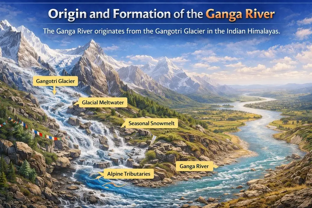
Emerging from the icy high-altitude environment, the river begins as a fast-flowing mountain stream fed by glacial meltwater, seasonal snowmelt, and numerous alpine tributaries. As the river descends from the rugged Himalayan terrain into the northern plains of India, it gradually transforms in character, widening and slowing while accumulating immense volumes of water and sediment.
Geological Importance
The formation and evolution of the Ganga River are deeply linked to major geological processes. The river’s existence is shaped by the uplift of the Himalayas, which created the gradient necessary for powerful downstream flow.

Glacial melt systems continuously supply freshwater, while sediment transport mechanisms carry mineral-rich particles across vast distances. Additionally, long-term tectonic shifts influence river courses and basin structure.
Over thousands of years, these forces enabled the Ganga to carve extensive alluvial plains, forming some of the world’s most fertile lands and supporting dense human settlement, agriculture, and civilization.
Historical Significance of the Ganga
Ancient Civilizations
The Ganga River played a transformative role in the rise of early civilizations across South Asia.
The fertile Ganga basin, enriched by nutrient-rich alluvial soils and a dependable freshwater supply, created ideal conditions for stable agricultural communities and expanding urban centers. Its navigable waters encouraged movement, trade, and interaction between distant regions.
Early societies relied on the river for drinking water, crop cultivation, and trade routes, while it also enabled vital cultural exchange. As a result, many of South Asia’s earliest cities and settlements flourished along its banks.
Religious and Spiritual Role
Few rivers in the world possess the profound spiritual significance of the Ganga River. In Hindu belief, the Ganga is worshipped as a divine goddess, symbolizing purity, renewal, and the cycle of life.
The river serves as a sacred site for ritual bathing, believed to cleanse sins, and is deeply connected to funeral rites, where ashes are immersed. Millions undertake pilgrimages to its banks, and countless festivals celebrate its sanctity. Over centuries, spiritual identity and river ecology became inseparably linked.
Medieval and Trade Networks
During the medieval era, the Ganga River functioned as a vital trade artery, connecting regions and sustaining economic life across northern India.
Its navigable channels enabled boats to transport goods, merchants, travelers, and cultural influences over long distances. River-based commerce became central to regional prosperity, linking rural producers with urban markets.
Trade along the river supported agricultural markets, encouraged the growth of craft industries, facilitated widespread cultural diffusion, and strengthened political administration by improving communication and resource movement between administrative centers.
Economic Role of the Ganga River
Agriculture
The Ganga floodplains represent some of the most productive agricultural lands globally. Seasonal flooding replenishes soil nutrients.
Major crops include:
- Rice
- Wheat
- Sugarcane
- Pulses
Transportation
Before modern rail and road networks, the river functioned as a primary transport corridor.
Fisheries
The river sustains significant freshwater biodiversity, supporting fishing communities and regional food systems.
Environmental Challenges
Despite its immense historical, cultural, and economic importance, the Ganga River faces serious environmental challenges that threaten its long-term health and sustainability.
Rapid urbanization, population growth, and industrial expansion have placed unprecedented pressure on the river’s ecosystem. One of the most critical issues is pollution, driven by untreated sewage, plastic waste, and chemical runoff entering the water.
Large volumes of urban waste discharge significantly degrade water quality, while industrial contamination introduces toxic substances that harm aquatic life and human health.
Additionally, reduced river flow in certain stretches, caused by upstream water diversion and climate variability, disrupts natural sediment transport and ecological processes. These combined pressures affect biodiversity, fisheries, and communities dependent on the river.
In response, various conservation and river restoration initiatives aim to improve water quality, regulate waste management, and restore ecological balance, highlighting the urgent need for sustainable river governance.
Part II – Transition from Ganga to Padma
How the Ganga Becomes the Padma River
As the Ganges River (Ganga) crosses the international boundary into Bangladesh, it undergoes a significant geographical and hydrological transformation, becoming the Padma River.
This transition is not merely a change in name but reflects complex environmental and physical processes shaped by regional topography and deltaic conditions. Upon entering Bangladesh’s low-lying plains, the river’s flow behavior, sediment load, and channel structure begin to adjust to a vastly different landscape.
This transformation represents a political boundary change, where a transboundary river enters a new national territory. It also involves hydrological redistribution, altering water dynamics across connected river systems.
Additionally, sediment reorganization reshapes riverbanks and floodplains, while continuous channel restructuring influences navigation, erosion patterns, and settlement distribution throughout the region.
Hydrological Transformation of the Padma River
The Padma River experiences a remarkable hydrological transformation as it flows through Bangladesh.
Unlike its relatively confined upstream section, the Padma River develops much wider channels downstream, especially during the monsoon season when water levels rise dramatically. One of the river’s most distinctive features is its braided channel structure, where multiple interwoven streams form around sandy shoals and temporary river islands known as chars.
This dynamic river system shows strong seasonal variability, with significant differences between dry and rainy seasons. Increased sediment transport, rapid channel shifting, and higher riverbank erosion rates make the Padma one of the most powerful and constantly changing rivers in South Asia.
Part III – The Padma River
Geographical Identity of the Padma River
The Padma River is one of the most powerful and influential rivers in Bangladesh, playing a crucial role in shaping the country’s geography, economy, and rural livelihoods.
As the main distributary of the Ganges after entering Bangladesh, the Padma carries an enormous volume of water and sediment throughout the year. It is widely known for its braided river system, where multiple dynamic channels split and rejoin around sandbars and temporary islands (chars).
The river transports a heavy sediment load, constantly reshaping its banks and surrounding landscapes. Strong seasonal flooding cycles during the monsoon further transform the river’s width, depth, and flow pattern, making it one of South Asia’s most dynamic river systems.
Historical Role in Bengal
The Padma River has played a vital historical role in shaping civilization across Bengal for centuries. As one of the region’s major river systems, it influenced settlement patterns, trade routes, and survival strategies for countless communities.
Fertile riverbanks supported thriving farming communities that relied on nutrient-rich alluvial soil for rice and crop production. The river also sustained vibrant fishing villages, providing food security and employment. Over time, busy market towns developed along its shores, serving as centers of commerce and cultural exchange.
In addition, the Padma functioned as a major transport hub, enabling boat trade and communication across Bengal, long before modern road and rail networks were established.
Riverbank Erosion and Human Adaptation
One of the Padma’s defining characteristics is erosion. Entire villages may vanish, while new lands emerge.
Chars – Living on Moving Land
Chars are sedimentary islands formed by deposition. Communities settle, farm, and rebuild repeatedly.
Life on chars reflects:
- Environmental uncertainty
- Resilience
- Adaptive livelihoods
Economic Importance of the Padma River
Agriculture
Sediment deposition sustains fertile soils ideal for:
- Rice cultivation
- Jute farming
- Vegetable production
Fisheries and Hilsa of the Padma River
The Padma River is legendary for its abundant Hilsa, locally known as Ilish, which is celebrated as the national fish of Bangladesh.
The Padma’s strong currents and rich sediment create an ideal breeding and migration route for Hilsa, making it one of the most productive fishing zones in the country. Hilsa fisheries play a crucial role in supporting thousands of riverine families, contributing significantly to the local economy and traditional Bengali cuisine.
Fishing traditions along the Padma are deeply rooted in generational knowledge passed down from father to son, including expert understanding of river behavior and fish movement. Fishermen carefully track seasonal Hilsa migration during monsoon and post-monsoon periods.
They use traditional nets and wooden boats designed specifically for the river’s dynamic currents. This blend of ecological wisdom, cultural heritage, and economic importance makes Hilsa fishing in the Padma an essential part of Bangladesh’s identity.
Transport and Connectivity
River routes remain vital, especially in rural regions where road access is limited.
Padma Bridge – Modern Transformation
The Padma Bridge stands as a powerful symbol of national pride, engineering ambition, and economic transformation in Bangladesh.
Spanning the mighty Padma River, this multipurpose road and rail bridge has reshaped the country’s transportation network and strengthened integration between the capital and the southern districts. Built with advanced engineering techniques to withstand strong currents and heavy sediment flow, the bridge marks a historic milestone in Bangladesh’s infrastructure development.
The impact of the Padma Bridge is profound. It has dramatically improved national connectivity, linking 21 southern districts directly with major economic centers. Travel times have been significantly reduced, allowing faster movement of people, goods, and services. Regional trade has expanded as agricultural products, fisheries, and industrial goods can now reach markets more efficiently.
In addition, the bridge has enhanced investment flows by attracting domestic and foreign investors to previously less-accessible regions. Overall, the Padma Bridge represents a new era of economic growth, regional development, and modern transformation for Bangladesh.
Cultural Life Along the Padma
Life along the Padma River is deeply rooted in river-centered traditions and seasonal rhythms. Communities living on its banks organize daily activities around fishing cycles, monsoon flood seasons, and agricultural timing.
Farmers depend on fertile alluvial soil deposited by annual floods, while fishermen adjust their work according to water levels and fish migration patterns. Boat transport remains essential for trade, travel, and communication, especially in remote char areas, sustaining a vibrant river-based culture in Bangladesh.
Folklore and Literature
The Padma frequently appears in Bengali storytelling, symbolizing both beauty and danger.
Food Culture
River ecosystems shape cuisine, particularly fish-based dishes central to Bangladeshi identity.
Ecological Importance
The river sustains complex ecosystems:
- Aquatic biodiversity
- Migratory species
- Wetland habitats
- Riverine vegetation
Climate Change Effects
Climate variability influences:
- Flood intensity
- Erosion rates
- Fish habitats
- Livelihood stability
Interconnected Significance of Ganga and Padma
A Shared River Heritage
The Ganges River and the Padma River represent a shared river heritage that transcends political borders. Though divided between India and Bangladesh, these rivers form one continuous hydrological system.
Water flow, sediment transport, and seasonal flooding patterns are interconnected, meaning upstream activities such as dam construction, irrigation withdrawal, and pollution directly influence downstream ecosystems. This cross-border river relationship highlights the importance of cooperative water management and sustainable development policies in South Asia.
Sediment and Delta Formation
Sediment carried from the Himalayan mountains through the Ganges system plays a crucial role in shaping Bangladesh’s vast deltaic landscape.
The continuous deposition of silt and alluvium forms fertile floodplains and supports the growth of the world’s largest delta, including areas near the Bay of Bengal. This process demonstrates strong regional dependence between upstream and downstream regions.
Socioeconomic Interdependence
Agriculture, fisheries, navigation, and ecological balance across India and Bangladesh depend on this shared river system.
Millions rely on its waters for food security, livelihoods, and transportation, proving that the Ganga–Padma river network is both environmentally and economically interconnected.
Why These Rivers Matter Globally
The Ganges River–Padma River river system is globally significant, extending far beyond regional importance in South Asia.
It forms one of the world’s largest river basins, supporting hundreds of millions of people across India and Bangladesh. The basin is a critical food production zone, sustaining vast rice fields, fisheries, and agriculture-based economies. It is also a biodiversity hotspot and a highly climate-sensitive ecosystem, vulnerable to glacial melt, flooding, and sea-level rise.
Conclusion
The Ganges River and the Padma River together form one of the most influential river systems in human history. Flowing across India and Bangladesh, this interconnected network has shaped civilizations, supported agriculture-based economies, and inspired spiritual and cultural traditions for thousands of years. From ancient settlements along their fertile banks to modern infrastructure projects, these rivers continue to define the social and economic landscape of South Asia.
The Ganga–Padma river system represents a powerful paradox of creation and destruction. While annual floods deposit nutrient-rich alluvial soil that strengthens food production, the same waters cause erosion, displacement, and environmental challenges. These rivers sustain millions of livelihoods through farming, fisheries, and trade, yet they also demand resilience and adaptive strategies. Understanding this river system is essential to understanding the history, culture, ecology, and climate reality of South Asia itself.