
Explore Farakka Barrage history, Ganges water dispute, 1996 treaty, environmental impact, and India–Bangladesh relations in this detailed 2026 guide.
1. Introduction to Farakka Barrage
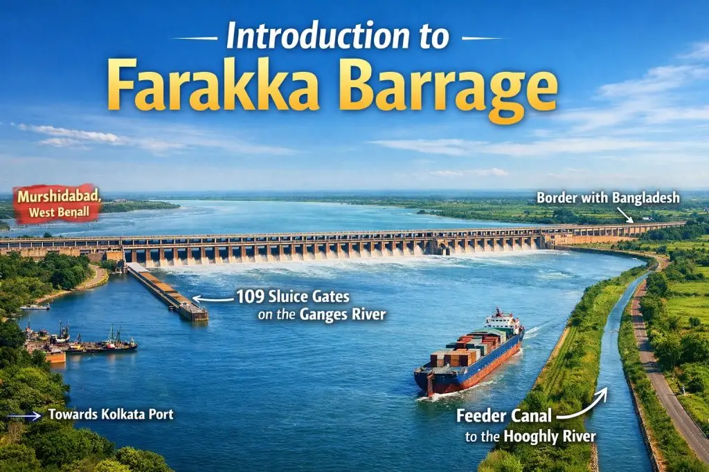
The Farakka Barrage is one of the most strategically important hydraulic structures in South Asia. Built across the mighty Ganges River, the barrage was primarily designed to divert water into the Hooghly River in order to restore and maintain the navigability of the historic Kolkata Port. At the time of planning, Kolkata Port was facing serious operational challenges due to heavy silt deposition in the Hooghly River, which reduced water depth and made navigation difficult for large vessels.
Geographically, the Farakka Barrage is located in the Murshidabad district of West Bengal, approximately 16 kilometers from the international border with Bangladesh. The structure stretches about 2.24 kilometers in length and contains 109 sluice gates that regulate the flow of water. In addition to the main barrage, a 38-kilometer-long feeder canal was constructed to carry water from the Ganges to the Hooghly River system.
Although the primary objective was economic—protecting river navigation and sustaining port activity—the barrage gradually evolved into a focal point of international debate. Its operation significantly influenced downstream water flow, turning it into a central issue in transboundary water-sharing discussions between India and Bangladesh.
2. Historical Background Before Construction Farakka Barrage
Colonial Period & River Navigation
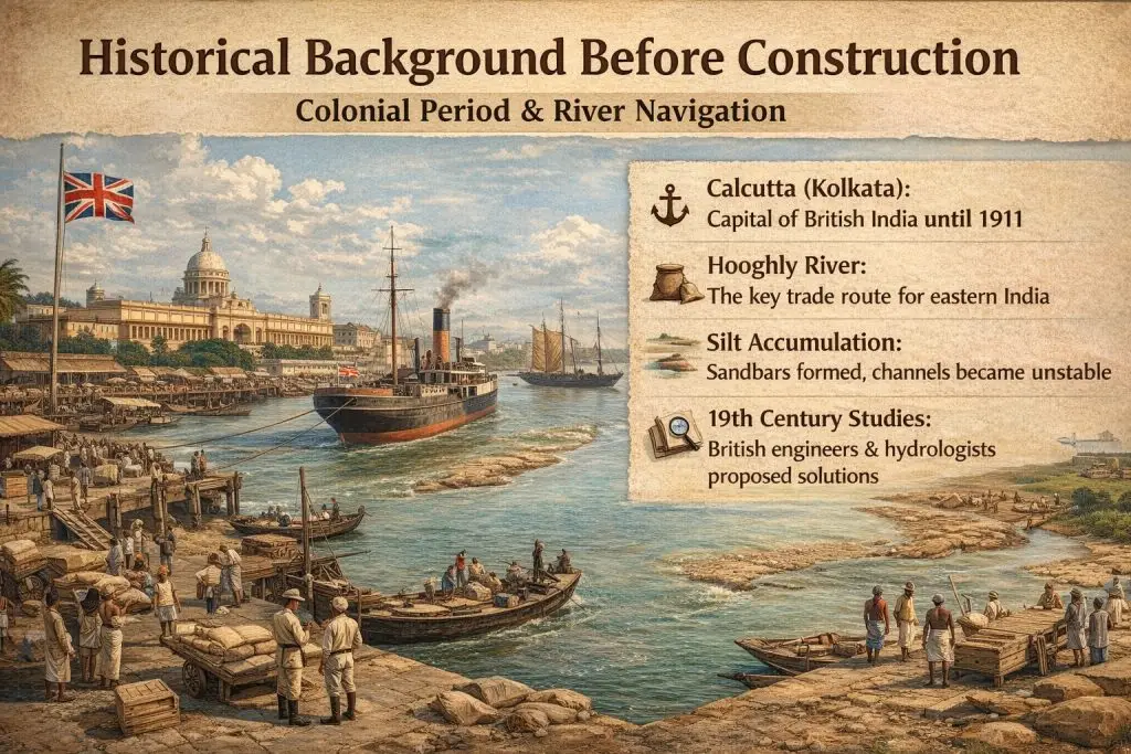
To understand the origin of the Farakka Barrage project, it is essential to examine the colonial history of eastern India. During British rule, Kolkata (then known as Calcutta) served as the capital of British India until 1911 and remained a major commercial hub even afterward. The Kolkata Port functioned as the primary gateway for trade in eastern and northeastern India, as well as parts of present-day Bangladesh and Nepal.
However, the Hooghly River, on which the port depended, is a highly sediment-laden river. Over time, silt accumulation became a serious problem. During dry seasons, reduced upstream water flow weakened the river’s natural capacity to flush sediments into the Bay of Bengal. As a result, sandbars formed, channels shifted, and navigation routes became unstable.
British engineers and hydrologists conducted multiple studies throughout the 19th and early 20th centuries. They concluded that the decline in navigability was largely due to insufficient freshwater discharge during lean seasons. Early proposals suggested diverting additional water from the Ganges to increase the flow of the Hooghly and flush out sediment deposits. While these ideas were technically discussed, they were not implemented during the colonial period due to financial and engineering limitations.
Nevertheless, the foundation for the Farakka concept was laid during this era, as engineers recognized that long-term river management would require upstream intervention.
3. Post-Independence Planning (1947–1960) Farakka Barrage

After India gained independence in 1947, the siltation issue in the Hooghly River became even more pressing. The newly independent nation faced the challenge of maintaining its key maritime trade routes while managing limited economic resources. The gradual decline in the operational efficiency of Kolkata Port raised concerns about regional trade and economic stability.
The Government of India initiated comprehensive hydrological and engineering studies to determine a permanent solution. Experts analyzed river discharge patterns, sediment transport, and seasonal water variability in the Ganges basin. These studies confirmed that diverting a controlled volume of water from the Ganges during the dry season could significantly improve sediment flushing in the Hooghly River.
The primary objectives of the Farakka project were clearly defined:
- Increase dry-season water flow in the Hooghly River
- Improve navigability for commercial vessels
- Protect Kolkata Port from economic decline
- Support irrigation and regional development
- Enhance overall river management infrastructure
The Farakka site was selected after detailed surveys. Engineers found that the river’s width, flow characteristics, and geographic positioning made it technically suitable for constructing a barrage. Its proximity to the Bangladesh border also meant that international water-sharing considerations would eventually become relevant, although this was not the primary focus at the time.
Planning during this period emphasized economic revival and technical feasibility, with less attention given to environmental and transboundary implications, which would later become significant.
4. Construction Phase (1961–1975) Farakka Barrage

Construction of the Farakka Barrage officially began in 1961 under the supervision of the Government of India. The project was ambitious for its time and required large-scale engineering coordination, financial investment, and logistical planning.
The major components of the project included:
- A 2.24-kilometer-long main barrage across the Ganges
- 109 sluice gates to regulate and control water discharge
- A 38-kilometer feeder canal to divert water to the Hooghly River
- Railway and road bridges built over the barrage
- Navigation locks to allow vessel movement
The barrage was designed not as a traditional storage dam but as a flow-control structure. Its primary function was to regulate and redirect water rather than create a large reservoir. The feeder canal played a crucial role by carrying diverted water directly toward the Hooghly River to improve its flushing capacity.
By 1975, the Farakka Barrage became fully operational. However, geopolitical developments dramatically altered its regional impact. In 1971, Bangladesh gained independence, transforming the Ganges into a shared international river between two sovereign nations. Once the barrage began diverting water during dry seasons, concerns arose in downstream Bangladesh about reduced water availability.
Thus, what began as an engineering solution to sedimentation evolved into a complex issue involving diplomacy, ecology, and international river law. The Farakka Barrage not only reshaped regional hydrology but also marked a turning point in South Asian water politics.
This expanded discussion provides a detailed, SEO-optimized overview of the early history and construction phase of the Farakka Barrage while maintaining clarity, originality, and keyword relevance.
5. Bangladesh Independence & Rising Tensions Farakka Barrage
In 1971, Bangladesh emerged as an independent nation after a historic liberation war that reshaped South Asia’s political landscape. With independence, the Ganges River system became an international river shared between India and Bangladesh. In Bangladesh, the Ganges is known as the Padma River, and it plays a critical role in agriculture, fisheries, transportation, and ecosystem stability.
When the Farakka Barrage became fully operational in 1975, Bangladesh began reporting significant reductions in dry-season water flow. The diversion of water into the Hooghly River during lean months (January to May) appeared to reduce the downstream discharge entering Bangladesh. For a deltaic country highly dependent on river water, even moderate changes in flow can have far-reaching consequences.
Major Concerns Raised by Bangladesh
1. Decline in Irrigation Water
Bangladesh relies heavily on surface water irrigation during the dry season to cultivate Boro rice and other crops. Reduced river discharge limited the availability of irrigation canals and groundwater recharge, affecting agricultural productivity in several western districts.
2. Reduced Fish Production
The Ganges–Padma system supports diverse freshwater fish species. Lower water levels and disrupted flow patterns affected breeding grounds and migratory routes, resulting in declining fish catches. This had economic consequences for fishing communities who depend on inland fisheries for income and nutrition.
3. Increased Salinity Intrusion
Reduced freshwater flow allowed saline water from the Bay of Bengal to move further inland. Salinity intrusion became a serious concern in southwestern Bangladesh, affecting soil fertility, drinking water supplies, and mangrove ecosystems.
4. Riverbank Erosion
Changes in river flow and sediment distribution altered river morphology. Certain areas experienced accelerated erosion, displacing communities and destroying farmland.
5. Impact on Navigation
Shallow water levels during the dry season disrupted traditional river transport routes, which are vital for trade and local connectivity.
These concerns collectively marked the beginning of what became widely known as the Farakka water dispute. The issue soon evolved from a technical water-management matter into a sensitive diplomatic topic between India and Bangladesh.
6. The 1996 Ganges Water Sharing Treaty Farakka Barrage
Following years of temporary water-sharing arrangements and negotiations, both countries signed the Ganges Water Sharing Treaty in December 1996. This agreement represented a major milestone in regional water diplomacy.
Key Features of the Treaty
30-Year Agreement (1996–2026)
The treaty established a structured water-sharing framework valid for 30 years, with provisions for review and renewal.
Water-Sharing Formula (January–May)
The agreement defined a detailed formula for distributing water during the dry season. It specified minimum guaranteed flows and sharing ratios depending on the availability of water at Farakka.
Monitoring Mechanisms
Joint monitoring committees were formed to measure water discharge and ensure transparency. Data sharing became a core component of the cooperation process.
Bilateral Cooperation Framework
The treaty emphasized mutual trust and long-term collaboration, setting a precedent for future water-sharing discussions in South Asia.
Although the treaty significantly reduced diplomatic tensions and stabilized bilateral relations, environmental concerns in Bangladesh did not entirely disappear. Critics argue that while the agreement regulates distribution, it does not fully address ecological restoration or climate-related uncertainties.
7. Environmental Impact of Farakka Barrage Farakka Barrage
The environmental consequences of the Farakka Barrage have been debated for decades. While the barrage serves important economic functions, it has also altered natural river dynamics.
7.1 Reduced Dry Season Flow
During the lean months between January and May, downstream flow into Bangladesh decreases compared to historical levels. Reduced discharge affects irrigation, domestic water supply, and aquatic ecosystems. Lower water levels can also concentrate pollutants, affecting water quality.
7.2 Salinity Intrusion
Freshwater flow from upstream rivers acts as a natural barrier against saline water from the Bay of Bengal. When discharge declines, saline water travels further inland, particularly in southwestern Bangladesh. Increased salinity damages crops, reduces soil fertility, and impacts freshwater biodiversity.
Salinity intrusion also threatens parts of the Sundarbans, the world’s largest mangrove forest and a UNESCO World Heritage Site. Changes in salinity levels can affect mangrove health and wildlife habitats.
7.3 River Morphology Changes
The Ganges–Padma river system is naturally dynamic, but controlled water diversion has influenced sediment movement patterns.
- Increased sediment deposition upstream of the barrage
- Erosion in downstream areas
- Channel shifting and instability
- Formation of new chars (river islands)
These changes can displace communities and complicate land-use planning.
7.4 Fisheries Decline
Migratory fish species depend on seasonal flow variations for breeding. Altered hydrological patterns disrupt these cycles. Reduced floodplain connectivity during dry seasons limits spawning habitats, contributing to declining fish populations in affected regions.
8. Economic Importance for India Farakka Barrage
Despite the controversy, the Farakka Barrage remains economically important for India.
Supports Kolkata Port Operations
By diverting water into the Hooghly River, the barrage improves sediment flushing and maintains navigable depth for vessels serving Kolkata Port. This supports regional trade and commerce.
Enhances Irrigation
The regulated flow benefits agricultural regions in West Bengal by stabilizing water availability for irrigation.
Rail and Road Connectivity
The barrage also functions as a transportation link, carrying railway and road infrastructure across the river, strengthening regional connectivity.
Boosts Regional Trade
Improved navigation and infrastructure contribute to economic activity in eastern India, supporting industries and supply chains.
Additionally, the barrage plays a role in flood moderation by controlling water discharge during peak monsoon flows, though it is not primarily a flood-control dam.
9. Socioeconomic Impact on Bangladesh
For Bangladesh, the Ganges–Padma system is more than a river—it is a lifeline. Communities downstream depend heavily on its waters for survival.
Rice Cultivation
Dry-season irrigation is critical for Boro rice production. Reduced water flow can limit crop yields and increase dependence on groundwater extraction.
Fisheries
Fishing communities rely on inland rivers for income and protein supply. Changes in fish stocks directly affect livelihoods.
River Transport
In rural Bangladesh, rivers serve as natural highways. Shallow channels during dry seasons disrupt cargo and passenger transport.
Livelihoods in Char Areas
Char dwellers depend on fertile river islands for agriculture. However, unstable river morphology increases vulnerability to erosion and displacement.
Reduced water availability during drought seasons intensifies poverty risks, especially among small farmers and landless households.
10. Climate Change & Future Challenges Farakka Barrage
Climate change adds a new layer of complexity to the Farakka issue. The Ganges basin originates in the Himalayas, where glacier melt and snowfall patterns influence long-term river flow.
Emerging Challenges
Changing Glacier Melt Patterns
Rising temperatures may initially increase meltwater, followed by long-term reductions as glaciers shrink.
Unpredictable Monsoon Variability
Climate change is altering rainfall patterns, causing irregular floods and prolonged dry spells.
Increasing Water Demand
Population growth, agriculture, and industry in both India and Bangladesh are raising water demand.
Sedimentation Issues
Ongoing sediment deposition remains a technical challenge for river management.
Treaty Renewal After 2026
The current Ganges Water Sharing Treaty expires in 2026. Negotiations for renewal will need to consider climate projections, ecological sustainability, and equitable allocation.
Future cooperation will require scientific collaboration, transparent data sharing, and integrated basin-wide management. Without coordinated planning, water scarcity and climate variability could intensify tensions.
11. Political & Strategic Significance of Farakka Barrage
The Farakka Barrage holds deep political and strategic importance in South Asia. More than a hydraulic structure, it represents the complex realities of managing shared rivers between neighboring nations. Since its commissioning in 1975, the barrage has stood at the center of discussions on transboundary water diplomacy between India and Bangladesh.
Transboundary Water Diplomacy
The Ganges River system flows across national borders, making cooperative water management essential. The Farakka Barrage became a test case for how two sovereign countries negotiate the allocation of shared natural resources. Diplomatic dialogue surrounding water distribution laid the foundation for structured agreements such as the Ganges Water Sharing Treaty.
Regional Geopolitics
Water is a strategic resource. Control over river flow can influence agriculture, trade, energy production, and environmental stability. As a result, Farakka is often viewed within a broader geopolitical framework involving regional security and economic development in South Asia.
Environmental Justice
In Bangladesh, critics argue that reduced dry-season water flow has disproportionately affected downstream communities, raising concerns about fairness and environmental equity. The debate highlights how infrastructure projects can create uneven benefits and burdens across borders.
Infrastructure vs Ecology Debate
The barrage symbolizes the global dilemma of balancing large-scale infrastructure with ecological sustainability. While it supports navigation and economic growth in India, it has also altered natural river dynamics, prompting environmental debates that continue today.
Because of these factors, Farakka remains central to India–Bangladesh relations and continues to influence diplomatic engagement in the region.
12. Technical Specifications of Farakka Barrage
The Farakka Barrage is an engineering structure designed primarily for water diversion and flow regulation rather than storage.
- Length: 2.24 kilometers
- Number of Gates: 109 sluice gates
- Feeder Canal Length: 38 kilometers
- Commissioned: 1975
- Location: Murshidabad district, West Bengal, India
The barrage diverts water from the Ganges River into the Hooghly River to improve sediment flushing and maintain navigability toward Kolkata Port. It also supports road and rail connectivity across the river, adding to its strategic infrastructure value.
13. Frequently Asked Questions
What is Farakka Barrage?
Farakka Barrage is a water-control structure built on the Ganges River in West Bengal, India. Its main purpose is to divert water into the Hooghly River to maintain navigable depth for shipping and protect Kolkata Port operations.
Why is Farakka Barrage controversial?
The barrage is controversial because its diversion of dry-season water has affected downstream flow into Bangladesh. This has raised environmental, agricultural, and economic concerns related to irrigation, fisheries, salinity intrusion, and river navigation.
When was Farakka Barrage built?
Construction began in 1961, and the barrage became fully operational in 1975.
What is the Ganges Water Sharing Treaty?
The Ganges Water Sharing Treaty is a 1996 agreement between India and Bangladesh that regulates dry-season water distribution at Farakka and establishes monitoring and cooperation mechanisms.
14. Conclusion
The Farakka Barrage stands as one of South Asia’s most debated hydraulic projects. Originally constructed to address navigation and sedimentation challenges in India, it later became a symbol of transboundary water conflict and cooperation. While it delivers economic and infrastructural benefits, it has also created environmental and diplomatic challenges downstream.
As the current treaty period approaches its 2026 deadline, both India and Bangladesh face a critical opportunity. Sustainable water-sharing strategies, climate adaptation planning, and continued diplomatic engagement will determine whether the Ganges evolves into a model of regional cooperation or remains a source of recurring tension.