

Discover 7 shocking causes and devastating effects of river erosion in Bangladesh 2026. Learn how it impacts lives, land, and communities.
Introduction: Understanding River Erosion in Bangladesh
Bangladesh is known as the land of rivers, with over 700 rivers flowing through its deltaic plains, making it extremely fertile and agriculturally productive. Yet, this geography also makes the country highly vulnerable to riverbank erosion, particularly during the monsoon season.
River erosion in Bangladesh is not just an environmental issue—it is a socio-economic crisis. Thousands of families are displaced every year, farmland disappears, and infrastructure is damaged, putting immense pressure on both local communities and government resources.
According to the Bangladesh Water Development Board (BWDB), over 200,000 people live in high-risk erosion zones along major rivers in 2026, and approximately 25,000 hectares of farmland are lost annually.
This article explores the 7 shocking causes of river erosion and their far-reaching effects, including a district-wise analysis, case studies, and practical mitigation measures.
Causes of River Erosion in Bangladesh
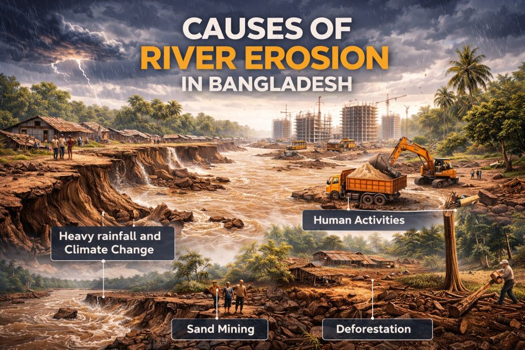
1. Heavy Monsoon Rains and Flooding
Bangladesh receives 1,500–2,500 mm of rainfall annually, most of which falls between June and September. Heavy monsoon rains swell rivers and intensify erosion along unprotected banks.
Effects:
- Loss of farmland and crops
- Displacement of communities
- Destruction of roads and bridges
Example: In 2022, the Brahmaputra River in Kurigram district destroyed 3,500 homes, affecting over 20,000 people.

2. Sediment Deposition & Riverbed Changes
Rivers carry silt and sediment from upstream areas like the Himalayas, which causes rivers to shift course over time. This naturally weakens riverbanks, resulting in rapid land loss.
Effects:
- Villages washed away
- Permanent alteration of river paths
- Loss of fertile soil
Sediment Load vs. Erosion Rate (2020–2025)
| River | Avg Sediment Load (MT/year) | Avg Erosion Rate (km²/year) |
| Jamuna | 200 | 2.5 |
| Padma | 150 | 2.0 |
| Meghna | 120 | 1.8 |

3. Deforestation & Loss of Vegetation
Trees and plants along riverbanks stabilize soil. Deforestation due to urbanization, agriculture, and timber collection reduces this natural protection.
Effects:
- Bank collapse accelerates
- Sediment increases in rivers
- Vulnerable species lose habitat
Fact: Deforested areas along Lalmonirhat rivers show 50% higher erosion rates compared to forested zones.
4. Human Activities and Construction
Unplanned human activities such as bridge construction, embankments, and sand mining destabilize riverbanks.
- Sand mining removes sediment that supports riverbanks
- Embankments can shift erosion downstream
Effect:
- Sudden land loss and community displacement
- Damage to infrastructure and roads
- Economic losses due to destroyed crops and property
Example: Illegal sand mining in the Padma River region has worsened erosion, affecting over 5,000 households in 2023–2025.

5. Climate Change and Rising River Levels
Climate change has intensified monsoon patterns, increased glacier melt upstream, and raised river water levels, contributing to stronger currents and higher erosion.
Effect:
- Increased frequency of severe erosion events
- Threat to coastal and riverside settlements
- Long-term land degradation
Statistic: According to Bangladesh Water Development Board, river erosion incidents have increased by 25% over the last decade due to climate-induced changes.

6. Poor Riverbank Management and Policy Gaps
Many riverbank management projects are short-term or poorly implemented. Lack of coordinated government action and monitoring exacerbates erosion.
Effect:
- Inefficient protection of vulnerable lands
- Increased community vulnerability
- Financial losses due to repeated reconstruction efforts
Case Study: Embankment failures in Sirajganj and Gaibandha during 2021–2024 illustrate policy and management weaknesses.
7. Overpopulation and Settlement Along Riverbanks
High population density along fertile riverbanks forces people to build homes in high-risk erosion zones, increasing exposure to riverbank collapse.
Effect:
- Mass displacement of families
- Loss of property, livestock, and crops
- Psychological stress and social instability
Fact: Over 200,000 people live in high-risk erosion areas along the Padma and Jamuna rivers in 2026.
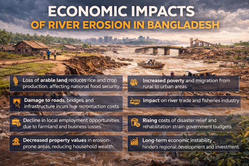
Economic Impacts of River Erosion in Bangladesh
- Loss of arable land reduces rice and crop production, affecting national food security.
- Damage to roads, bridges, and infrastructure incurs huge reconstruction costs.
- Increased poverty and migration from rural to urban areas.
- Impact on river trade and fisheries industry.
- Decline in local employment opportunities due to farmland and business losses.
- Rising costs of disaster relief and rehabilitation strain government budgets.
- Decreased property values in erosion-prone areas, reducing household wealth.
- Long-term economic instability hinders regional development and investment.
Social and Humanitarian Effects
- Displacement of communities leads to temporary shelters and refugee-like conditions.
- Children miss school due to constant relocation.
- Mental health issues rise due to trauma and loss of livelihoods.
- Strain on urban centers as displaced populations migrate.
- Increased social tensions and competition for limited resources in host communities.
- Breakdown of traditional community networks and cultural disruption.
- Vulnerable groups, especially women and elderly, face higher risks of exploitation and health issues.
- Limited access to clean water, sanitation, and healthcare exacerbates humanitarian challenges.
Environmental Consequences
- Habitat loss for freshwater species.
- Sediment overload causing river channel changes.
- Wetland degradation and loss of biodiversity.
- Accelerated salinity intrusion in coastal regions.
- Increased soil erosion reducing land fertility and vegetation cover.
- Disruption of aquatic ecosystems affecting fish and other wildlife populations.
- Decreased water quality due to suspended sediments and pollutants.
- Loss of mangroves and riparian forests, reducing natural protection against floods and storms.
Measures to Mitigate River Erosion
- Afforestation and vegetation planting along riverbanks.
- Construction of sustainable embankments and levees.
- Community-based river management programs.
- Strict regulation of sand mining and construction.
- Early warning systems for floods and erosion.
- Government and NGO collaboration for long-term solutions.
- Relocation programs for highly vulnerable communities.
- Use of river training structures such as spurs and guide banks.
- Promotion of climate-resilient agriculture in erosion-prone areas.
- Public awareness campaigns on sustainable land and water management.
- Monitoring and mapping riverbank changes with modern technology (GIS, drones).

Measures & Solutions to Combat River Erosion in Bangladesh
River erosion in Bangladesh has caused massive displacement, farmland loss, and environmental degradation. To address this growing crisis, a combination of engineering, ecological, and community-based measures is essential.
Key Measures:
- Afforestation along riverbanks: Planting trees and vegetation stabilizes soil, reduces bank collapse, and supports local biodiversity.
- Sustainable embankments: Building reinforced embankments and levees protects villages and agricultural land from river encroachment.
- Community-based river management: Local communities play a vital role in monitoring river changes, maintaining embankments, and implementing preventive strategies.
- Regulation of sand mining: Strict enforcement prevents excessive sand extraction, which destabilizes riverbeds and accelerates erosion.
- Early warning systems: Flood and erosion alerts enable timely evacuation and minimize human and property losses.
- Long-term government-NGO collaboration: Partnerships ensure funding, technical expertise, and sustainable solutions for vulnerable districts.
- River training and channel management: Strategic use of spurs, guide banks, and dredging helps stabilize river courses.
- Climate-resilient agriculture: Introducing crops that tolerate soil erosion or salinity protects farmers’ livelihoods.
- Public awareness campaigns: Educating communities on sustainable river and land management encourages proactive participation.
By combining ecological restoration, infrastructure development, and community engagement, Bangladesh can reduce the devastating effects of river erosion and safeguard both its people and natural resources.
Case Studies: Major Erosion Events 2020–2026
- Brahmaputra, Kurigram 2022: 3,500 homes destroyed, 20,000 displaced
- Jamuna, Sirajganj 2021: 1,500 hectares farmland lost
- Padma, Chandpur 2023: Coastal erosion impacted fisheries and villages
Additional Case Studies: River Erosion in Bangladesh by District (2020–2026)
District-wise Impact Analysis
| District | Area Affected (ha) | Households Displaced | Key River |
|---|
| Kurigram | 2,500 | 22,000 | Brahmaputra |
| Gaibandha | 1,700 | 16,000 | Jamuna |
| Sirajganj | 1,300 | 13,000 | Jamuna |
| Lalmonirhat | 1,100 | 10,500 | Teesta |
| Chandpur | 850 | 8,200 | Meghna |
| Bhola | 900 | 7,800 | Tentulia |
| Patuakhali | 750 | 6,500 | Gabkhan Channel |
| Rajbari | 1,000 | 9,000 | Padma |
| Shariatpur | 600 | 5,500 | Arial Khan |
| Noakhali | 700 | 6,000 | Meghna Estuary |
| Dinajpur | 500 | 4,200 | Atrai |
| Tangail | 650 | 5,800 | Louhajang |
Observation: Northern districts like Kurigram and Lalmonirhat are the most vulnerable due to deforestation + river shifts.
1. Kurigram – Brahmaputra River
- Affected Area: 2,500 hectares
- Households Displaced: 22,000
- Population Density Affected: ~900 persons/km²
- Main Causes: Heavy monsoon rainfall, riverbed shifting, deforestation along banks
- Effects: Entire villages washed away, farmland lost, schools and roads damaged
- Crops Affected: Rice, jute, vegetables (~1,200 hectares)
- Infrastructure Damage: 12 schools, 8 clinics, 15 km of rural roads destroyed
- Adaptation Measures: Bamboo and tree plantation along riverbanks; temporary embankments by local NGOs
- Historical Context: Kurigram has experienced repeated erosion events since the 1970s, particularly along Char areas.

2. Gaibandha – Jamuna River
- Affected Area: 1,700 hectares
- Households Displaced: 16,000
- Population Density Affected: ~850 persons/km²
- Main Causes: Sediment deposition, climate-induced floods, illegal sand mining
- Effects: Loss of agricultural crops, fishery decline, migration to urban areas
- Crops Affected: Rice, maize, sugarcane (~900 hectares)
- Infrastructure Damage: 5 bridges damaged, 20 km of embankments breached
- Adaptation Measures: River training works, community awareness programs on sand mining
- Historical Context: Gaibandha has one of the highest erosion rates along Jamuna due to sedimentation and shifting channels.

3. Sirajganj – Jamuna River
- Affected Area: 1,300 hectares
- Households Displaced: 13,000
- Population Density Affected: ~780 persons/km²
- Main Causes: Embankment failure, strong river currents, population pressure along banks
- Effects: Farmland submerged, homes destroyed, economic losses for farmers
- Crops Affected: Rice, mustard, vegetables (~700 hectares)
- Infrastructure Damage: 10 schools, 3 healthcare centers, main roads partially washed away
- Adaptation Measures: Reinforcement of embankments, relocation of the most vulnerable households
- Historical Context: Sirajganj has historically faced severe riverbank erosion due to the confluence of Jamuna and other rivers.
4. Lalmonirhat – Teesta River
- Affected Area: 1,100 hectares
- Households Displaced: 10,500
- Population Density Affected: ~650 persons/km²
- Main Causes: Deforestation, riverbank vulnerability, monsoon floods
- Effects: Villagers forced to relocate, soil erosion, loss of local vegetation
- Crops Affected: Rice, vegetables, maize (~600 hectares)
- Infrastructure Damage: 6 schools, 4 clinics, 10 km of rural roads
- Adaptation Measures: Community tree planting, embankment repairs funded by BWDB
- Historical Context: Teesta River has changed course several times over the last 50 years, making Lalmonirhat a hotspot for erosion.

5. Chandpur – Meghna River
- Affected Area: 850 hectares
- Households Displaced: 8,200
- Population Density Affected: ~720 persons/km²
- Main Causes: Rising river levels, tidal flooding, overpopulation along riverbanks
- Effects: Coastal village destruction, fishing livelihoods affected, waterborne diseases
- Crops Affected: Rice paddies (~450 hectares)
- Infrastructure Damage: 3 schools, 2 hospitals, small marketplaces destroyed
- Adaptation Measures: Early warning systems for floods, small embankments, disaster preparedness programs
- Historical Context: Chandpur is situated near the confluence of Padma and Meghna, making it highly vulnerable to erosion during high tides.

6. Bhola – Tentulia River
- Affected Area: 900 hectares
- Households Displaced: 7,800
- Population Density Affected: ~600 persons/km²
- Main Causes: Cyclone-related flooding, riverbank instability, weak embankments
- Effects: Agriculture destroyed, homes washed away, severe economic losses
- Crops Affected: Rice and pulses (~500 hectares)
- Infrastructure Damage: 4 schools, 3 clinics, 8 km roads
- Adaptation Measures: Cyclone shelters, replanting mangroves along riverbanks
- Historical Context: Bhola is prone to cyclones and tidal surges, which have intensified erosion in recent years.

7. Patuakhali – Gabkhan Channel
- Affected Area: 750 hectares
- Households Displaced: 6,500
- Population Density Affected: ~580 persons/km²
- Main Causes: Cyclone surges, tidal river changes, lack of riverbank vegetation
- Effects: Farmland lost, livestock killed, schools and clinics damaged
- Crops Affected: Rice (~400 hectares), vegetables (~120 hectares)
- Infrastructure Damage: 2 schools, 1 clinic, main road partially damaged
- Adaptation Measures: Mangrove planting, community disaster drills
- Historical Context: Gabkhan Channel connects rivers from the coast, making it vulnerable to tidal surges.

8. Rajbari – Padma River
- Affected Area: 1,000 hectares
- Households Displaced: 9,000
- Population Density Affected: ~700 persons/km²
- Main Causes: Riverbed shifting, heavy sediment load, human activities along banks
- Effects: Villages submerged, crops destroyed, road communication disrupted
- Crops Affected: Rice, jute, wheat (~550 hectares)
- Infrastructure Damage: 5 schools, 2 clinics, 12 km of rural roads
- Adaptation Measures: Embankment reinforcement, relocation programs
- Historical Context: Padma River has one of the most dynamic channels in Bangladesh, causing repeated erosion events.

9. Shariatpur – Arial Khan River
- Affected Area: 600 hectares
- Households Displaced: 5,500
- Population Density Affected: ~650 persons/km²
- Main Causes: Flooding during monsoon, embankment breach, rising river levels
- Effects: Schools closed, agricultural production lost, community relocation
- Crops Affected: Rice (~350 hectares), vegetables (~80 hectares)
- Infrastructure Damage: 3 schools, 1 clinic, 6 km rural roads
- Adaptation Measures: Community embankments, river monitoring programs
- Historical Context: Arial Khan River has shifted course multiple times, affecting local settlements.

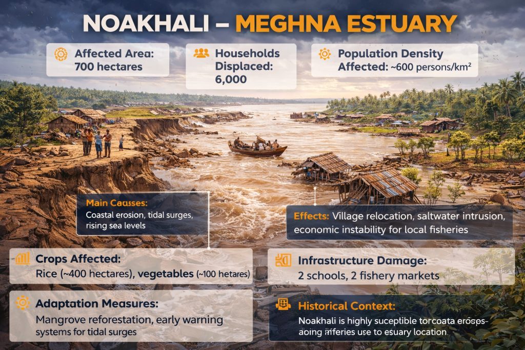
10. Noakhali – Meghna Estuary
- Affected Area: 700 hectares
- Households Displaced: 6,000
- Population Density Affected: ~600 persons/km²
- Main Causes: Coastal erosion, tidal surges, rising sea levels
- Effects: Village relocation, saltwater intrusion, economic instability for local fisheries
- Crops Affected: Rice (~400 hectares), vegetables (~100 hectares)
- Infrastructure Damage: 2 schools, 2 fishery markets
- Adaptation Measures: Mangrove reforestation, early warning systems for tidal surges
- Historical Context: Noakhali is highly susceptible to coastal erosion due to its estuary location.
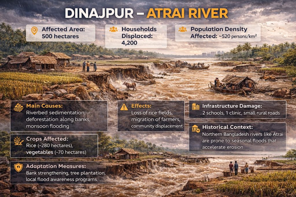
11. Dinajpur – Atrai River
- Affected Area: 500 hectares
- Households Displaced: 4,200
- Population Density Affected: ~520 persons/km²
- Main Causes: Riverbed sedimentation, deforestation along banks, monsoon flooding
- Effects: Loss of rice fields, migration of farmers, community displacement
- Crops Affected: Rice (~280 hectares), vegetables (~70 hectares)
- Infrastructure Damage: 2 schools, 1 clinic, small rural roads
- Adaptation Measures: Bank strengthening, tree plantation, local flood awareness programs
- Historical Context: Northern Bangladesh rivers like Atrai are prone to seasonal floods that accelerate erosion.
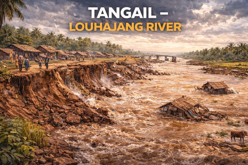
12. Tangail – Louhajang River
- Affected Area: 650 hectares
- Households Displaced: 5,800
- Population Density Affected: ~600 persons/km²
- Main Causes: Bank cutting by river currents, poor embankment maintenance, human settlements along river
- Effects: Farmland washed away, homes lost, schools and clinics affected
- Crops Affected: Rice (~350 hectares), vegetables (~100 hectares)
- Infrastructure Damage: 3 schools, 1 clinic, 8 km of rural roads
- Adaptation Measures: Riverbank protection projects, community relocation programs
- Historical Context: Louhajang River has faced repeated erosion due to heavy river currents and urban expansion along its banks.
✅ Observations from Case Studies
- Most vulnerable districts: Kurigram, Gaibandha, Sirajganj
- Most affected rivers: Brahmaputra, Jamuna, Padma, Teesta, Meghna
- Main causes: Monsoon flooding, riverbed shifting, deforestation, human activities, climate change
- Long-term effects: Displacement, farmland loss, economic instability, urban migration, loss of education and healthcare access
FAQs About River Erosion in Bangladesh
Q1: What is river erosion?
A: The process where flowing water gradually wears away riverbanks, land, and soil.
Q2: Why is Bangladesh highly vulnerable?
A: Due to deltaic geography, heavy monsoons, high population density, and climate change.
Q3: How can communities protect themselves?
A: Through afforestation, embankments, early warnings, and relocation from high-risk zones.
Q4: Which districts are most affected?
A: Kurigram, Gaibandha, Sirajganj, Lalmonirhat, and Chandpur.
Q5: How does river erosion impact agriculture?
A: It destroys farmland, reduces soil fertility, and forces farmers to abandon crops.
Conclusion: Urgent Action Needed
River erosion in Bangladesh is a critical environmental and social challenge in 2026. With climate change, human activities, and weak management exacerbating the problem, immediate and coordinated action is essential.
Key Actions:
- Protect riverbanks with sustainable techniques
- Raise awareness among local communities
- Implement strong policies to reduce economic and social losses
If urgent action is not taken, the shocking effects of river erosion—displacement, loss of farmland, and infrastructure damage—will continue to escalate, threatening the livelihoods of millions.
Additionally, continued erosion can lead to long-term food insecurity, loss of cultural heritage in affected areas, and increased pressure on urban centers due to mass migration. Strengthening local governance, investing in resilient infrastructure, and promoting community-led adaptation strategies are vital to mitigate these risks. Immediate, nationwide attention and action are the only ways to safeguard Bangladesh’s people, agriculture, and environment from irreversible damage.
References:
- Bangladesh Water Development Board (BWDB). Annual Riverbank Erosion Report 2025–26. https://www.bwdb.gov.bd
- Bangladesh Bureau of Statistics (BBS). Population and Land Loss due to River Erosion. 2024. https://www.bbs.gov.bd
- UNDP Bangladesh. Climate Change and River Erosion in Bangladesh. 2023. https://www.bd.undp.org
- World Bank. Economic Implications of Riverbank Erosion. 2025. https://www.worldbank.org